QGraphicsView 实例3地图浏览器
主要介绍Graphics View框架,实现地图的浏览、放大、缩小,以及显示各个位置的视图、场景和地图坐标
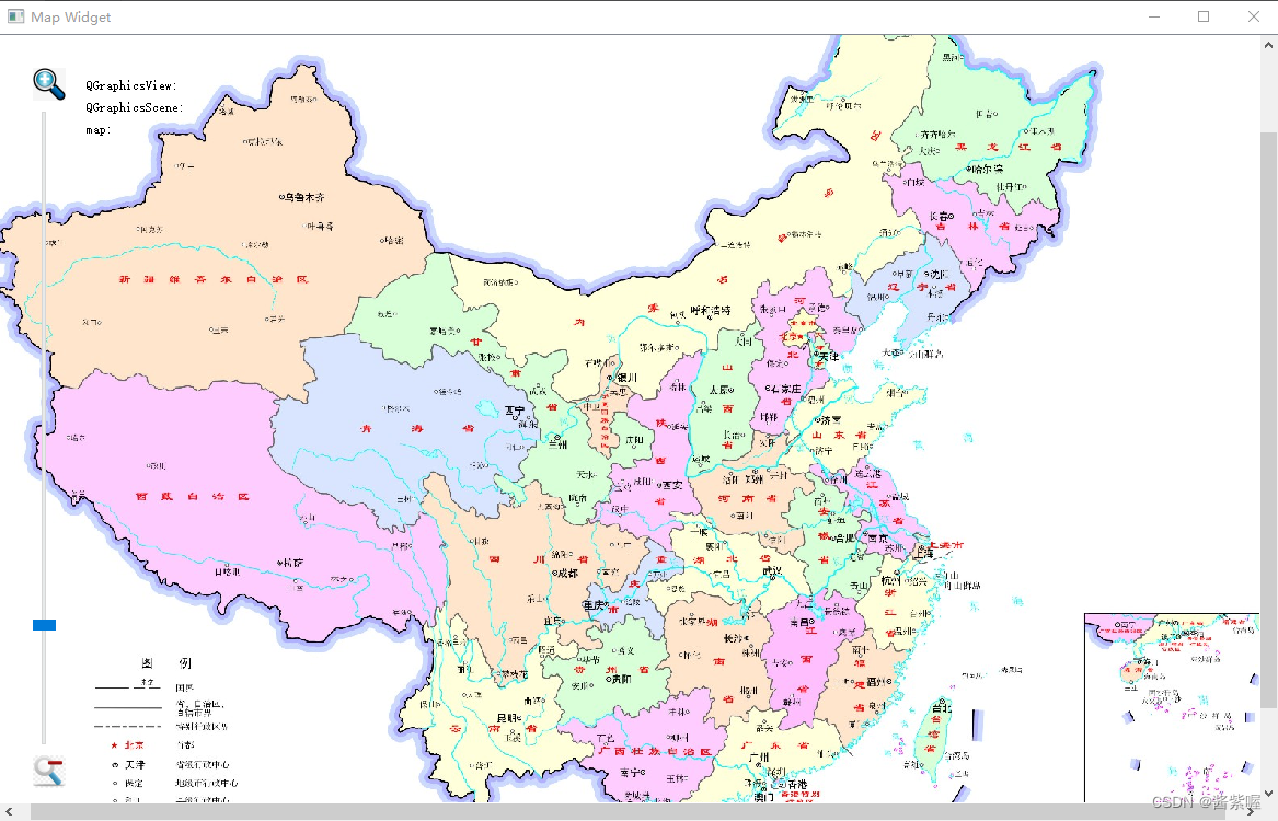
效果图:
mapwidget.h
#ifndef MAPWIDGET_H
#define MAPWIDGET_H
#include <QLabel>
#include <QMouseEvent>
#include <QGraphicsView>class MapWidget : public QGraphicsView
{
public:MapWidget();void readMap();QPointF mapToMap(QPointF);    //实现场景坐标系与地图坐标之间的映射,以获得某点的经纬度值public slots:void slotZoom(int);QPixmap map;
protected:void  drawBackground(QPainter *painter,const QRectF &rect);  //完成地图显示的功能void  mouseMoveEvent(QMouseEvent * event);private:qreal zoom;QLabel *viewCoord;QLabel *sceneCoord;QLabel *mapCoord;double  x1,x2;double y1,y2;};#endif // MAPWIDGET_H
mapwidget.cpp
#include "mapwidget.h"
#include <QSlider>
#include <QGridLayout>
#include <QVBoxLayout>
#include <QHBoxLayout>
#include <QFile>
#include <QGraphicsScene>
#include <QTextStream>
#include <math.h>
#include <QLabel>/* 1、setCacheMode(CacheBackground)这个属性控制view的那一部分缓存中,QGraphicsView可以预存一些内容在QPixmap中,
* 然后被绘制到viewpoint上,这样做的目的是加速整体区域重绘的速度,例如:质地、倾斜度、和最初的混合背景可能重绘很缓慢,
* 尤其是在一个变形的view中,CacheBackground标志使能view的背景缓存,例如
* QGraphicsView view;
* view.setBackgroundBrush(QImage(":/images/backgroundtile.png"));
* view.setCacheMode(QGraphicsView::CacheBackground);
* 每次view转换后cache就无效了,然而,当滚动区域时候,只有部分无效默认的,没有使用cache
* 2、setTickInterval(int)来设置发射信号的间隔,一般都设置为1000ms,就是1s发射一次
* 3、setScaledContents(bool)这个属性保存标签是否按这个图片的比例填满所用的可用空间,默认false*/MapWidget::MapWidget()
{//读取地图信息,包括地图的名称,经纬度等readMap();zoom=50;int width=map.width();int height=map.height();QGraphicsScene *scene=new QGraphicsScene(this);scene->setSceneRect(-width/2,-height/2,width,height);setScene(scene);setCacheMode(CacheBackground);//用于地图缩放的滑动条QSlider *slider=new QSlider;slider->setOrientation(Qt::Vertical);slider->setRange(1,100);slider->setTickInterval(10);slider->setValue(1);connect(slider,&QSlider::valueChanged,[=](int t_value){slotZoom(t_value);});;QLabel *zoomin=new QLabel;zoomin->setScaledContents(true);zoomin->setPixmap(QPixmap(":/image/zoomin.jpg"));zoomin->setFixedSize(30,30);QLabel *zoomout=new QLabel;zoomout->setScaledContents(true );zoomout->setPixmap(QPixmap(":/image/zoomout.jpg"));zoomout->setFixedSize(30,30);//坐标值显示区QLabel  *label1=new QLabel(QStringLiteral("QGraphicsView:"));viewCoord=new QLabel;QLabel  *label2=new QLabel(QStringLiteral("QGraphicsScene:"));sceneCoord=new QLabel;QLabel  *label3=new QLabel(QStringLiteral("map:"));mapCoord=new QLabel;//坐标显示区布局QGridLayout *gridLayout=new QGridLayout;gridLayout->addWidget(label1,0,0);gridLayout->addWidget(viewCoord,0,1);gridLayout->addWidget(label2,1,0);gridLayout->addWidget(sceneCoord,1,1);gridLayout->addWidget(label3,2,0);gridLayout->addWidget(mapCoord,2,1);gridLayout->setSizeConstraint(QLayout::SetFixedSize);QFrame *coordFrame=new QFrame;coordFrame->setLayout(gridLayout);//坐标显示布局QVBoxLayout *coordLayout=new QVBoxLayout;coordLayout->addWidget(coordFrame);coordLayout->addStretch();//缩放控制子布局QVBoxLayout *zoomlayout=new QVBoxLayout;zoomlayout->addWidget(zoomin);zoomlayout->addWidget(slider);zoomlayout->addWidget(zoomout);//主布局QHBoxLayout *mainLayout = new QHBoxLayout;mainLayout->addLayout(zoomlayout);mainLayout->addLayout(coordLayout);mainLayout->addStretch();mainLayout->setMargin(30);mainLayout->setSpacing(10);setLayout(mainLayout);setWindowTitle(QStringLiteral("Map Widget"));setMinimumSize(600,400);}
void MapWidget::readMap()  //读取地图信息
{QString mapName;QFile mapFile(":/image/China.txt");int ok=mapFile.open((QIODevice::ReadOnly | QIODevice::Text));  //以"只读"方式打开此文件if(ok){QTextStream ts(&mapFile);if(!ts.atEnd()){ts >> mapName;ts>>x1>>y1>>x2>>y2;}}mapFile.close();map.load(":/image/China.jpg");     //将地图读取至私有变量map中}//根据缩放滑动条的当前值,确定当前缩放的比例
void MapWidget::slotZoom(int value)
{/** 检测value(slider改变得到的值),与当前value值得大小比较* pow(x, y)表示x的y次方* slider改变的值大于zoom值时,增加缩放比例* slider改变的值小于zoom值时,减小缩放比例* scale(s, s)将当前的视图换为(s, s)*/qreal s;if(value>zoom)  //放大{s=pow(1.01,(value-zoom));}else{s=pow(1/1.01,(zoom-value));}scale(s,s); //实现地图的缩放zoom=value;}//以地图图片重绘场景的背景来实现地图显示
void MapWidget::drawBackground(QPainter *painter, const QRectF &rect)
{painter->drawPixmap(int(sceneRect().left()),int(sceneRect().top()),map);
}//完成某点在坐标上的映射和显示
void MapWidget::mouseMoveEvent(QMouseEvent *event)
{//QGraphicsView坐标QPoint viewpoint=event->pos();viewCoord->setText(QString::number(viewpoint.x())+","+QString::number(viewpoint.y()));//QGraphicsScene坐标QPointF scenePoint=mapToScene(viewpoint);sceneCoord->setText(QString::number(scenePoint.x())+","+QString::number(scenePoint.y()));//地图坐标(经纬度)QPointF latLon= mapToMap(scenePoint);mapCoord->setText(QString::number(latLon.x())+","+QString::number(latLon.y()));}QPointF MapWidget::mapToMap(QPointF p)
{QPointF latLon;qreal w=sceneRect().width();qreal h=sceneRect().height();qreal lon=y1-((h/2+p.y())*abs(y1-y2)/h);qreal lat=y1-((w/2+p.x())*abs(x1-x2)/w);latLon.setX(lat);latLon.setY(lon);return latLon;
}